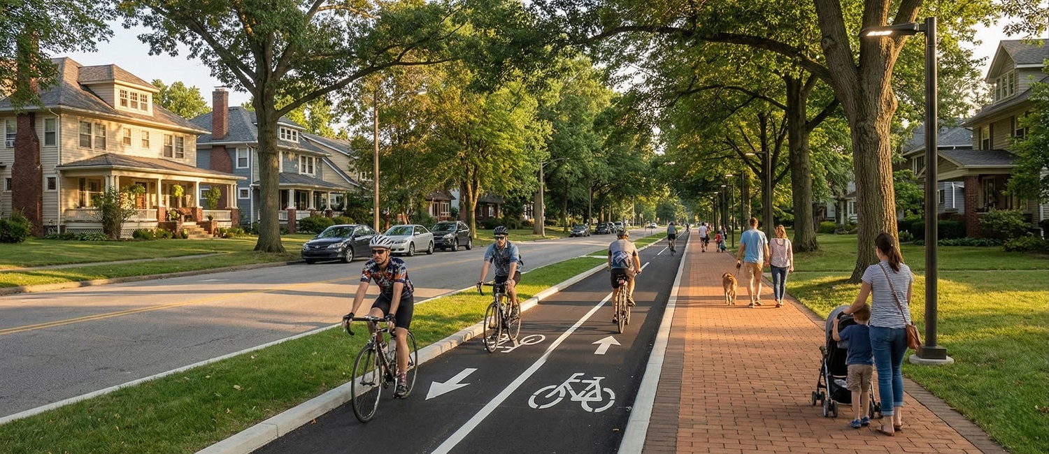
A conceptual rendering of a shared-use path along West Boulevard linking several of Cleveland’s west-side neighborhoods (contributed). CLICK IMAGES TO ENLARGE THEM.
State awards planning funds to project
State and local officials announced this week that the State of Ohio awarded $100,000 to the City of Cleveland to develop plans for a shared-use path for cyclists, joggers, pedestrians and others living in or visiting the city’s West Boulevard, Cudell, Clifton-Baltic and Edgewater neighborhoods.
State Rep. Tristan Rader, D-13, along with Cleveland’s Ward 11 Councilwoman Nikki Hudson and Ward 12 Councilman Tanmay Shah made the announcements in joint video statements posted on Facebook.
A Community Project application was submitted for the trail funding last March by Hudson and Shah, and supported by Rader. The funding was included in the State Capital Budget but still had to be awarded through an administrative application process.
Hudson and Shah both pledged as-yet unidentified, future Cleveland City Council discretionary funds to develop an off-street, shared-use path along the wide, city-owned tree lawn of a portion of historic West Boulevard.
They said the goal is to more easily connect area residents and regional visitors to Edgewater Park and encourage neighborhood residents and people using Greater Cleveland Regional Transit Authority’s Red Line trains to walk, bike, and use alternative and healthy lifestyle methods to gain access to the park versus driving.
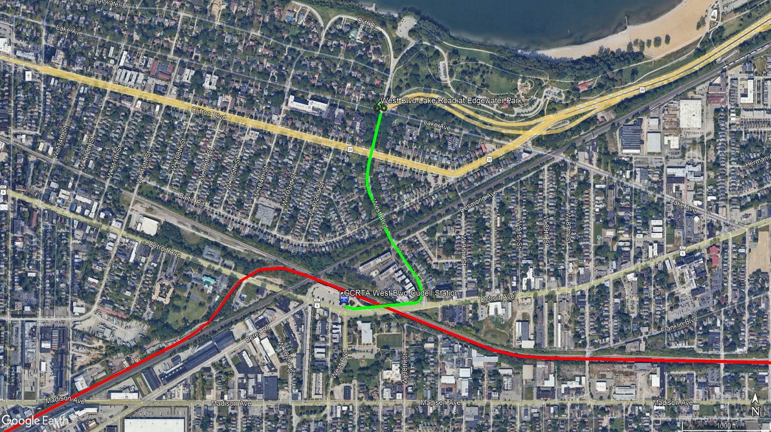
The green line shows the first phase of proposed West Boulevard Shared Use Path, linking Edgewater Park and the West Blvd-Cudell Station on the light-rail Red Line (Google).
“This is a cool partnership between the state and the city to do a shared-use path that is going to connect Cudell Park to Edgewater,” Rader said in a written statement.
“Cleveland needs to put more measures in place that will allow cyclists and pedestrians the ability to travel around the city more safely,” Hudson added.
The immediate area around West Boulevard from Detroit Avenue to Lake Avenue is highly popular, often utilized by families and crowds of people to park and walk to Edgewater Park during special events and holidays, such as Independence Day in two days.
Pedestrians reach the park from the south either via West Boulevard and cross Clifton Boulevard, or they head down Baltic Road and cross over Lake Avenue to the loop path that tunnels under the Shoreway and into the park.
“We live in a city because we do not want to have to get around everywhere by driving a car,” Shad said. “This project is a great way to make that more of a reality in Cleveland, making it safer and easier for other types of transportation.”
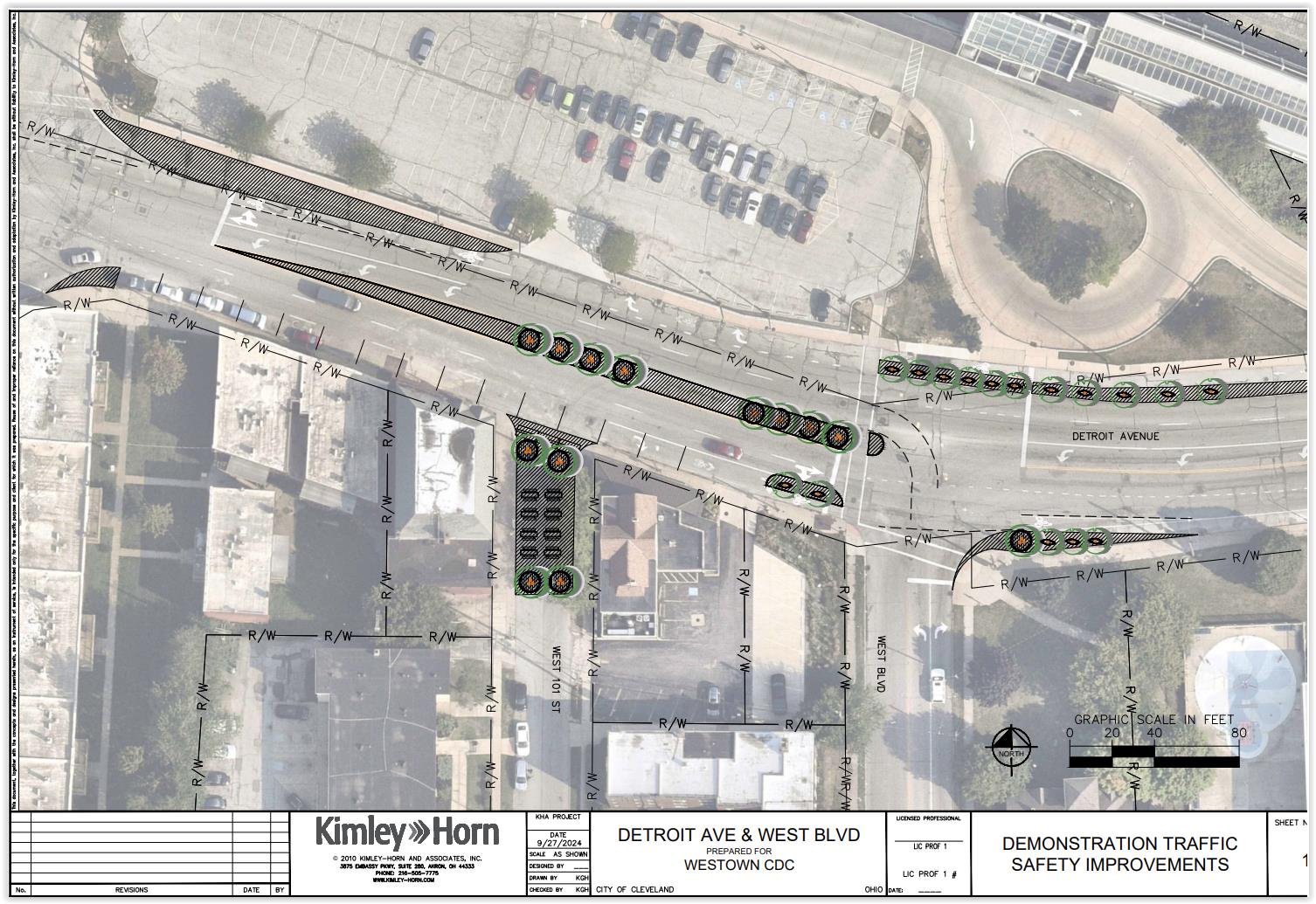
Conceptual improvements to Detroit Avenue to make it easier and safer to the cross the street to the Red Line Rapid station have been proposed for a couple of years but have yet to be realized (Westown CDC).
Community input will shape the planning process that will be carried out by a design consultant who has yet to be hired via a city-led request for proposals.
The Ward 11 Council Office will begin collecting community input for the project planning through in-person community meetings and through an online submission form. Community input sessions will be announced in the near future.
“We want the people of both wards 12 and 11 to feel heard and be a part of this process,” Shah said.
Once a final plan has been formed, the West Boulevard Shared Use Path could be implemented in three phases. The first phase would connect Edgewater Park to Detroit Avenue and the Red Line station via West Boulevard.
The second phase would connect the rapid transit station, Cudell Commons Park, Cudell Recreation Center and Fine Arts Center, and the Depot on Detroit, 10300 Detroit.
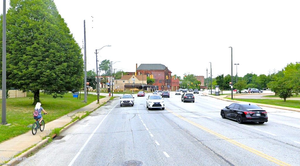
A wide street is not only more difficult to cross but it also encourages motorists to drive faster than a narrow street would. This is Detroit Avenue with the Cudell Recreation Center on the left and the West Blvd-Cudell Red Line station on the right (Google).
The latter is a 60-unit housing development that is under construction west of the Red Line rapid transit station. This stretch of Detroit has been proposed for improvements to make it safer for pedestrian and cyclists to cross, thus improving the station’s links to the surrounding neighborhood.
Phase three could extend the shared-use path from Cudell Recreation Center to the intersection of West Boulevard and Madison Avenue. Additional funding following the completion of Phases 1-3 could see the path continue further south, the councilpersons said.
“It is our hope that this project will help spur traffic-calming on the portion of where Detroit Avenue meets West Boulevard,” Hudson said. “Crossing that section of Detroit Avenue can be intimidating and downright dangerous.”
In the late 19th-century, Cleveland’s leaders hoped green spaces would combat the congestion and grime caused by rapid population growth and industrialization. Cities across the country adopted similar systems of parks and boulevards as they designed new neighborhoods for the increasing number of urban residents.
Although West Boulevard links urbanized neighborhoods, all homes facing the boulevard adhere to strict deed restrictions that mandate far setbacks and wide tree lawns – giving a verdant, suburban atmosphere to the street. But Cleveland’s ambitious plans by the city’s planners of yesteryear, to connect every park, were never fully realized.
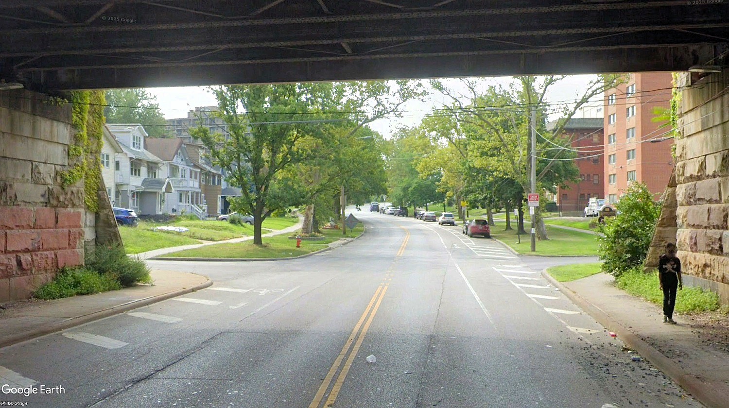
West Boulevard’s underpass below the busy Norfolk Southern railroad tracks could be enhanced for pedestrians, cyclists and others traveling between Edgewater Park and the Cudell neighborhood to the south (Google).
The historic West Boulevard Allotment subdivision was a carefully planned neighborhood within Cleveland’s Parks and Boulevards system, an ambitious scheme to connect Cleveland’s parks with wide, spacious boulevards and parkways.
West Boulevard begins as an entrance to Edgewater Park; it was supposed to connect to Brookside Park in the south, but that plan was not ultimately realized.
However, the numerous mature trees, far setbacks and high standards of architecture on West Boulevard are living testaments to this important era of city planning in American history. Most of the homes were built in a construction boom between 1910-1920.
People driving up and down the boulevard are still greeted by homes offering gabled roofs, generous porches, and green lawns. In 2000, this section of West Boulevard was named the Clifton & West Boulevard Historic District.
“Cleveland has enough vehicles on our streets,” Hudson added. “We’re working together to put more of a focus on people and families, not cars.”
END