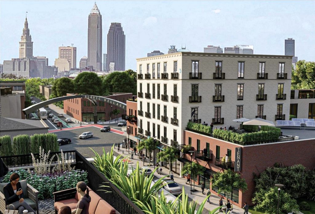
A vision for turning downtown Cleveland’s under-developed and underutilized lakefront into a more enjoyable place will be unveiled July 27 by city officials. It will reportedly include preliminary designs for the North Coast Connector, remake of the Shoreway into a boulevard, phases of mixed-use developments, and possibly some cost-benefit data associated with the closing and repurposing of Burke Lakefront Airport (Google). CLICK IMAGES TO ENLARGE THEM.
Preliminary plans will be subjected to public input
Although the downtown lakefront plans to be released publicly on July 27 will be preliminary, they will give more insight into the direction city officials received from prior public input sessions on developing the city’s “front porch” as officials call the city’s Lake Erie waterfront. And since these plans are still preliminary and conceptual, city officials said they want more public input on them before refining them and adding more design details to them.
To that end, city officials are inviting residents to join a panel discussion and open house on the North Coast Master Plan from 3-5 p.m. July 27 at the Great Lakes Science Center, 601 Erieside Ave. an upcoming panel discussion and open house. The event will be hosted by Mayor Justin Bibb and the city’s lakefront master planning team. The panel discussion will be from 3 to 4 p.m. followed by an open house and interactive discussion from 4 to 5 p.m. Space is limited, and light refreshments will be provided, so registration is required.
The event is accessible by public transit and parking is suggested in the Great Lakes Science Center garage. Those interested should visit clevelandnorthcoast.com or call 216-664-2210. This event will share initial thoughts and sketches for the emerging North Coast Master Plan, which has been shaped by the community’s vision acquired through meetings, surveys and interviews, city officials said.
Attendees will have the opportunity to engage in a moderated discussion with a panel that will include Bibb and the planning team, gaining insight into the vision and direction of the plan. After this discussion, interactive exhibits will be available for participants to provide feedback on the preliminary plans and share additional ideas. It remains to be seen if the future of Burke Lakefront Airport will be on the table at this event. In the spring, the city hired Econsult Solutions of Philadelphia to perform a four-month, $115,000 study on the economic costs and benefits of closing the airport, the land use options as well as assessing the regulatory hurdles. Data from that study may not be available for another month or two.
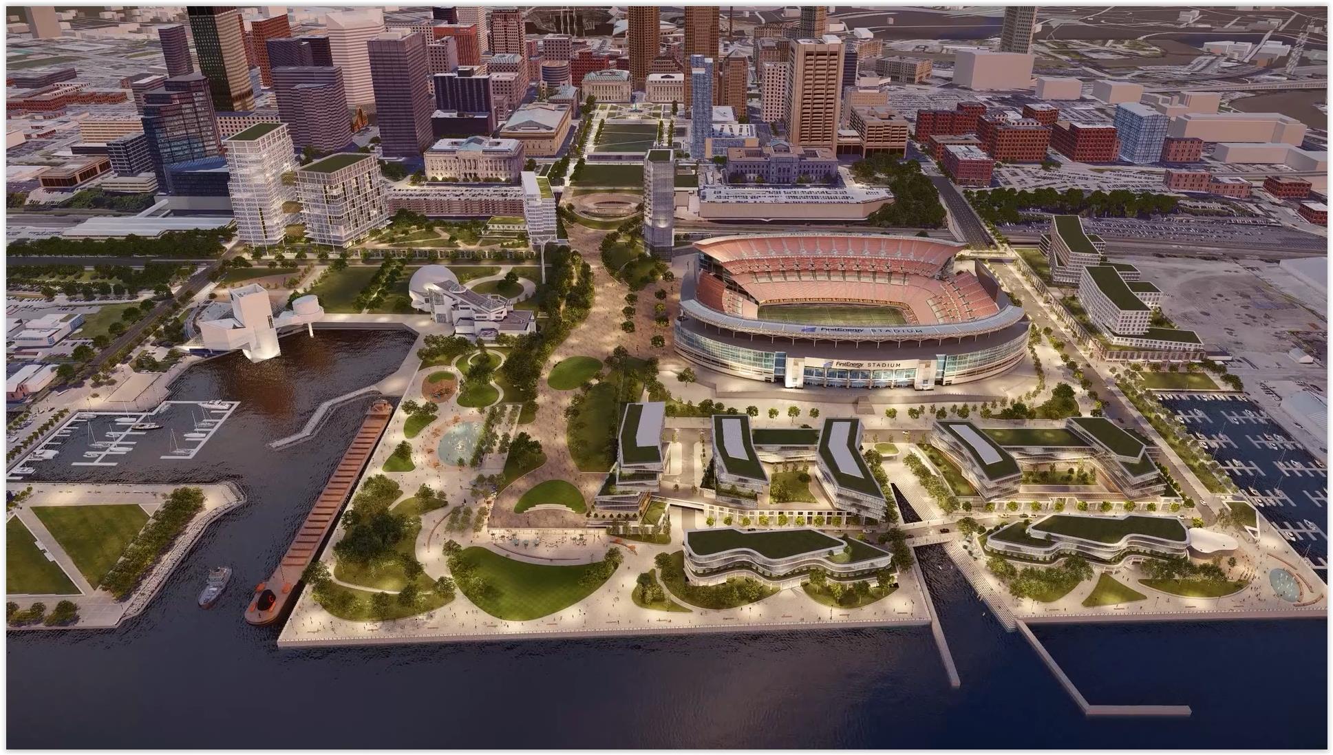
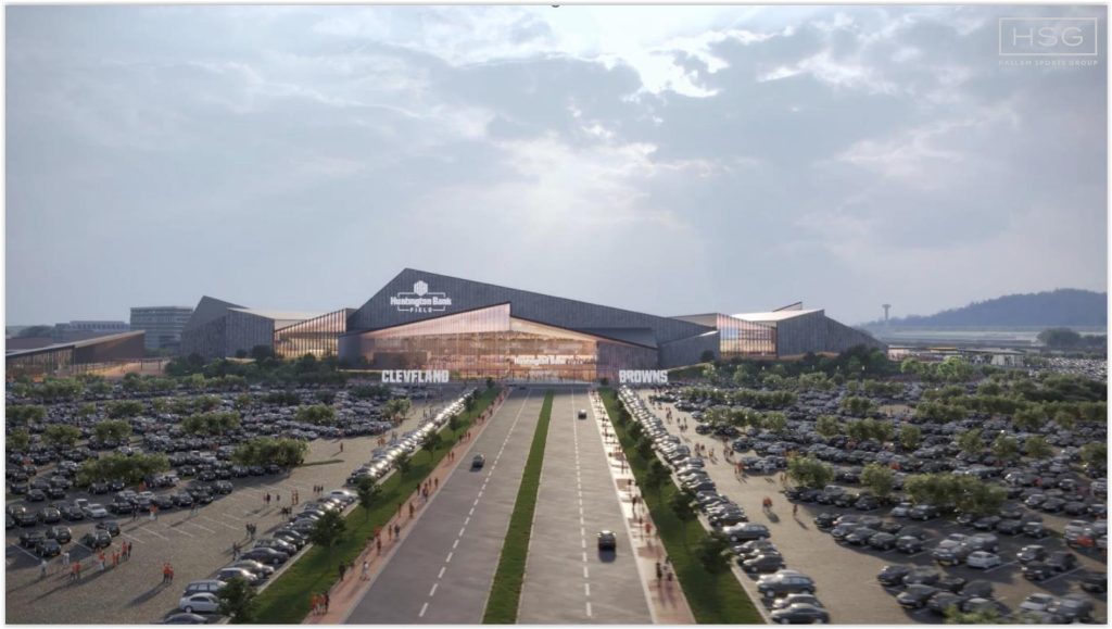
Redeveloping downtown’s lakefront with year-round land uses including public spaces, housing, restaurants and shops means moving 2,000 parking spaces on the water’s edge to somewhere else to satisfy the Cleveland Browns’ lease with the city over the use of the football stadium. Those parking spaces could be incorporated into the proposed land bridge, shown here to the left of the stadium (AoDK).
“We have a way to go and a lot more listening to do before this plan is settled,” Bibb said in a written statement. “But it’s exciting to see these first ideas taking shape. We can see a bold vision for the North Coast, and it’s all inspired and guided by what we’ve heard from the community.”
This event is just the beginning of a series of opportunities for community involvement and throughout the summer the North Coast Lakefront project team will be at grocery stores, neighborhood festivals and parks to gather input citywide. City officials said they are seeking ongoing feedback and ideas from Clevelanders over the coming months, as the North Coast Master Plan continues to develop. Ideas are continuously collected online, at clevelandnorthcoast.com.
Many residents have publicly expressed skepticism that this is just another lakefront plan that will grow stale and dusty on a shelf. But city officials said that such plans — with public involvement — must be done in order for infrastructure elements of the lakefront vision to be eligible for federal construction funds. One of the more important and expensive elements of the lakefront vision will be the North Coast Connector.
With an estimated construction cost of $200 million or more, plus ongoing costs to operate and maintain it, the North Coast Connector would provide a land bridge to link downtown and the waterfront over the busy lakefront railroad tracks and Shoreway highway. According to sources, the land bridge would have a landscaped roof with walking and biking paths and act as an extension of the downtown malls all the way north to the water’s edge.
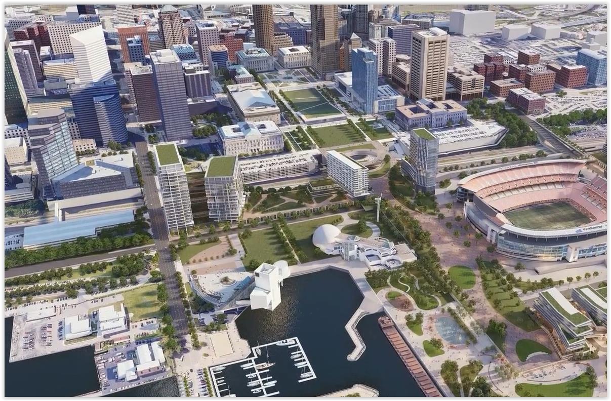
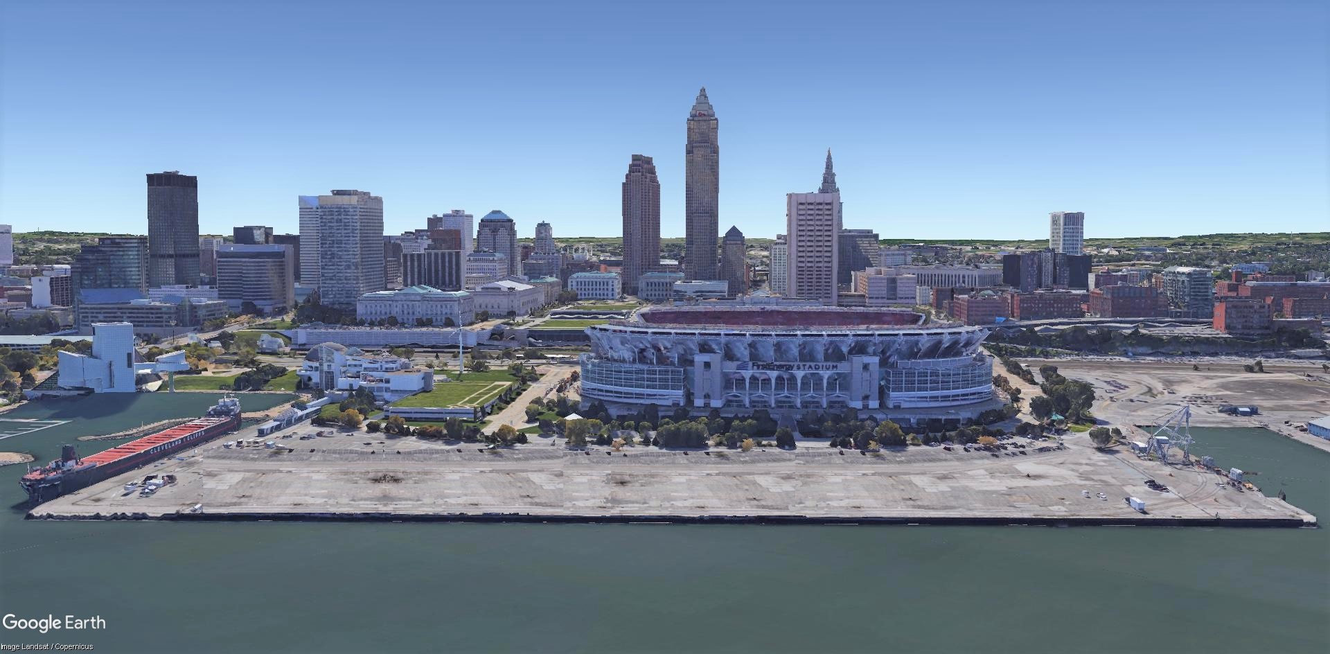
This rendering shows how a North Coast Connector could continue the downtown malls at top-center, straight over the railroad tracks and the Shoreway-turned-boulevard, to the water’s edge at lower-right. The land bridge could pass between Cleveland Browns Stadium at far-right and the Great Lakes Science Center to the left of it (AoDK).
Below the roof, it would have multiple levels of parking to support future development and provide a minimum number of parking spaces for the Cleveland Browns as guaranteed by the city’s lease with the football team for use of the stadium. The connector could allow the removal of parking lots between the stadium and the lake so they can be developed with housing, restaurants, shops and public spaces. High-rise apartment buildings are also planned next to the land bridge and the railroad tracks. The economic viability of those towers would be bolstered by parking provided within the North Coast Connector.
Proposed on the ground level of the connector is a multimodal transportation center including a new Amtrak train station and a new Waterfront Line light-rail transit stop that combines and replaces two nearby stations — the 27-year-old West 3rd-Browns Stadium and North Coast-East 9th stations. A new roadway traveling below West 3rd and East 9th streets and linking the Port of Cleveland to the highway system east of downtown is planned as well.
To build a North Coast Connector between the stadium and the science center so that it makes a straight, continuous, descending alignment from the downtown malls to the water’s edge, the Shoreway may have to be removed. North of the malls, the Shoreway starts to rise on a bridge that takes it over the railroad tracks and West 3rd. That bridge and the fact that it’s a limited-access highway creates another physical barrier between central business district and the lakefront.
So the city is likely to seek converting the Shoreway into a boulevard with intersections at West 3rd, Erieside Avenue, East 9th and possibly an extension of East 18th Street. It remains to be seen how a new boulevard would traverse West 3rd and link up with the Main Avenue Bridge over the Flats. One option would be to route the boulevard over West 3rd and its bridge over the railroad tracks, then gently ramp up onto the Main Avenue Bridge. The other would have the new boulevard cross West 3rd, then turn south on its own bridge over the railroad tracks, before curving west again to ramp up onto the bridge over the Flats.
END