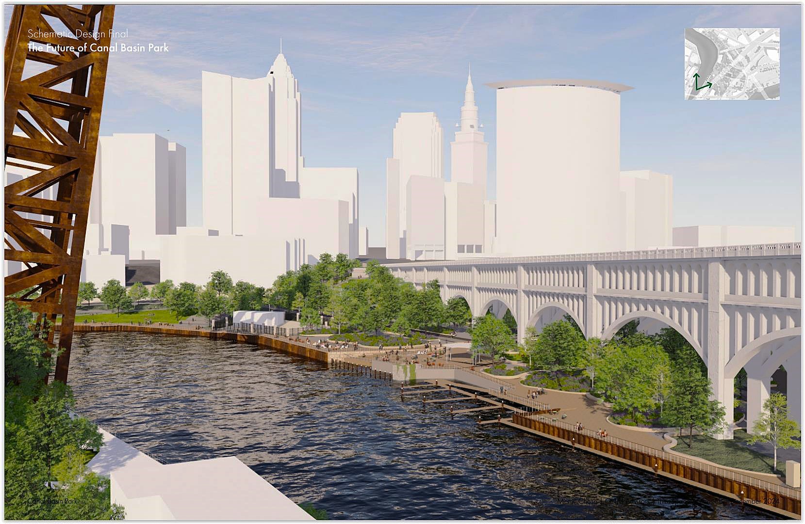
Downtown Cleveland’s Canal Basin Park, as viewed from near the old Superior Viaduct, shows the newly added boat docks and the planned boardwalk along the Cuyahoga River. Designs for the park offer features that are both fun and educational for people of all ages (Merritt Chase). CLICK IMAGES TO ENLARGE THEM.
Planning Commission offers ideas for schematic plan
Although Cleveland Planning Commission’s Design-Review Committee gave a unanimous thumbs-up today to conceptual plans for downtown’s Canal Basin Park, it wasn’t without some suggestions for improvement. The design team for the 20-acre park, located between turns in the curvaceous Cuyahoga River, will come back to the commission with refined, more detailed schematic designs in the coming months.
Although it’s too soon for a hard cost estimate for rebuilding and expanding the existing the park, which is mostly city-owned parking lots, the schematic design and construction documents to be developed for the park will help refine what, at this point, is a $35 million rough guess. It will also help fundraising efforts, said Dan Shinkle, Downtown-Flats planner for the city.
“We’re starting the fundraising and really trying to get some shovels in the ground here,” he said at today’s Planning Commission meeting. Shinkle described the project, which is more than a decade in the making, as “pivotal, interesting and exciting” and it will “tell some unique Cleveland stories.”
So far, $850,000 in state funds were earmarked for Canal Basin Park through the Ohio Department of Natural Resources. But those funds, provided through last year’s State Capital Budget, are to be shared with the Irishtown Bend Park project, which also is in need of more funds to round out its $45 million wish list of park programming.

This map showing the location of Canal Basin Park and its existing and planned links to other public parks and spaces was often referred to at today’s Planning Commission meeting as to why this project needs to happen. But planners also said there were gaps in the connections to other assets which, it was hoped, this park could help motivate remedies (Merritt Chase).
In presenting the plans, Shinkle was joined by the city’s Senior Landscape Architect James McNight, and other members of the park’s design team, which included consultants Merritt Chase of Pittsburgh, as well as OHM Advisors and ThirdSpace Action Lab, both of Cleveland.
Planned improvements to the existing park, where a dog park and boat dock were recently built, include a boardwalk, stormwater basin, garden, Cuyahoga River-themed playground, open spaces for community events and stone boulders from historic buildings and bridges, plans show.
Also, Merwin Road could become a pedestrian promenade linking Superior Avenue hill and Settlers Landing Plaza with Center Street bridge and Detroit Avenue. The park would gain a Mile Zero Plaza to celebrate the terminus of the Towpath Trail that was extended north four years ago into downtown from the Cuyahoga Valley National Park and the larger Ohio and Erie Canalway National Heritage Corridor that extends 101 miles south to New Philadelphia.
Indeed, the park’s strategic location was cited by just about everyone attending today’s meeting as a key to unlocking lots of potential connections between trails, parks, neighborhoods, emerging developments and even historical and environmental awareness.
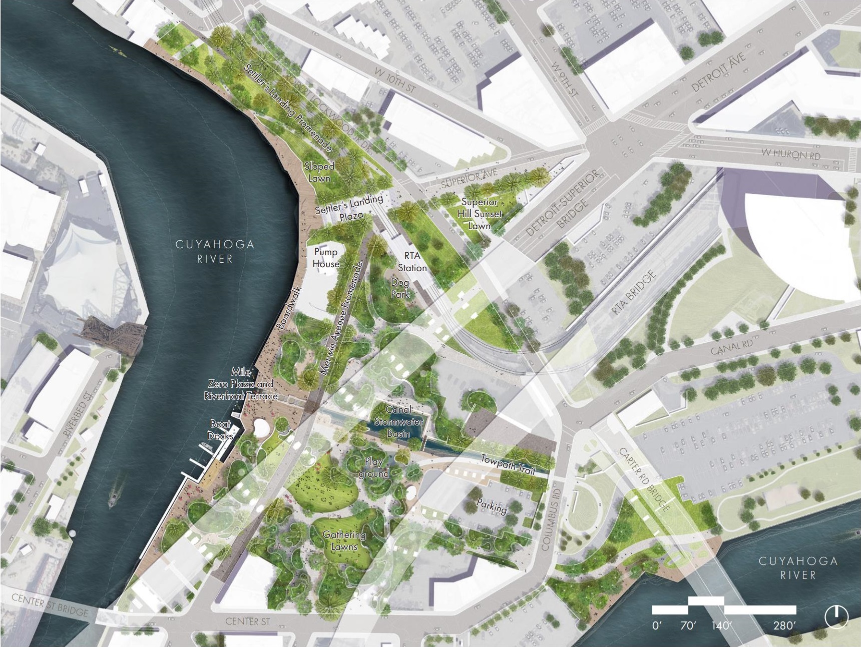
Final, conceptual site plan for Canal Basin Park, with labels identifying its features including the existing Towpath Trail, dog park and boat docks, plus the planned boardwalk, mile zero plaza, riverfront terrace, playground, gathering lawns, canal stormwater basin, Merwin Avenue converted to a pedestrian promenade, Superior Hill sunset lawn, and a parking lot (Merritt Chase).
This was the northern terminus of the Ohio and Erie Canal, the construction of which began here 200 years ago this July, to link the Great Lakes with the Ohio and Mississippi rivers and turned Cleveland from a struggling wilderness port village into a major city. The hand-dug canal reached Akron in two years and the Ohio River in seven, said Mera Cardenas, executive director of Canalway Partners which turns 40 years old this year.
“Cleveland’s historic growth, success and cultural makeup are directly connected to the Ohio and Erie Canal,” Cardenas said. “By transforming an historic site at the canal’s basin to an interpretive park we will be embedding and honoring this history in the physical essence of downtown Cleveland.”
Hired consultant Nina Chase, principal and co-founder of Merritt Chase, said the defining features of the park are its location on the river and it being the terminus of the Towpath Trail. She also noted that the site is surrounded by Wendy Park, Irishtown Bend Park, Rivergate Park, Bedrock’s riverfront development, Public Square and more.
“Canal Basin Park really sits in the middle of all this,” Chase said. “It has the potential to truly connect lots of really wonderful connections that have been built over many years with many partners.”
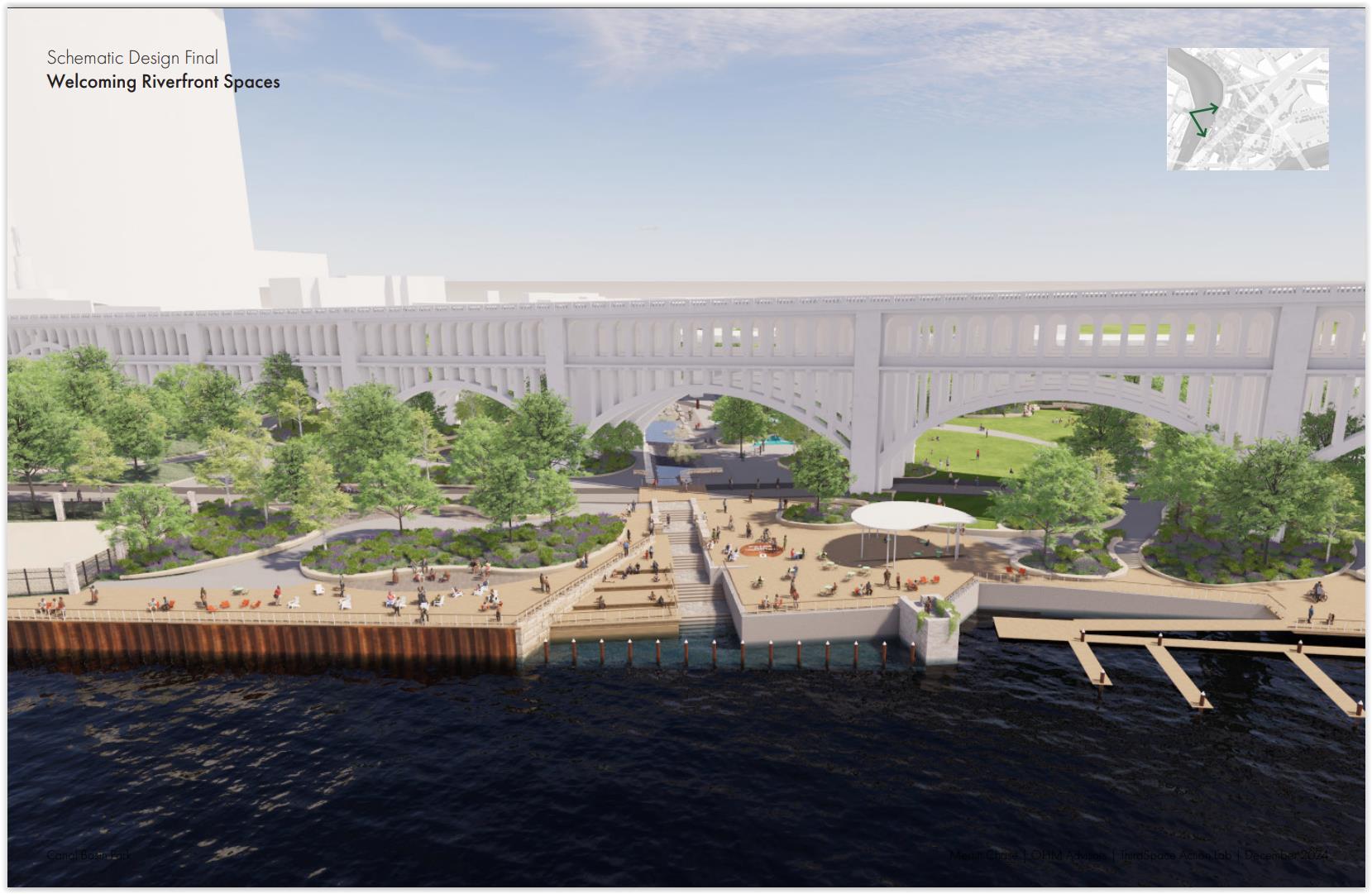
View of Canal Basin Park from the Cuyahoga River showing the planned boardwalk, mile zero plaza and riverfront terrace where the mouth of the Ohio and Erie Canal was. At right is the existing boat docks and, at left, an existing pump house. The Detroit-Superior High Level Bridge forms the backdrop (Merritt Chase).
The park’s proposed design built on six key themes — history and identity, context and connectivity, inclusion and belonging, amenities and programming, infrastructure and utilities, plus funding and operations.
Planning Commission Chair Lillian Kuri said that projects like this are often thought of as transformative but they never achieve their full potential because they remain isolated from other community assets. She said the park’s plans need to identify the gaps that need to be filled in to create a continuous publicly accessible riverfront boardwalk.
With Canal Basin Park being the terminus of the Towpath Trail, there’s an opportunity to make a left or right turn to link up with community assets like Settlers Landing Park, Flats East Bank, downtown, Irishtown Bend Park, Ohio City and more. With efforts by the Cleveland Metroparks to build riverfront boardwalks and Bedrock’s riverfront development to add boardwalks below Tower City Center, Kuri said there’s an opportunity to have a mile-long boardwalk along the east bank.
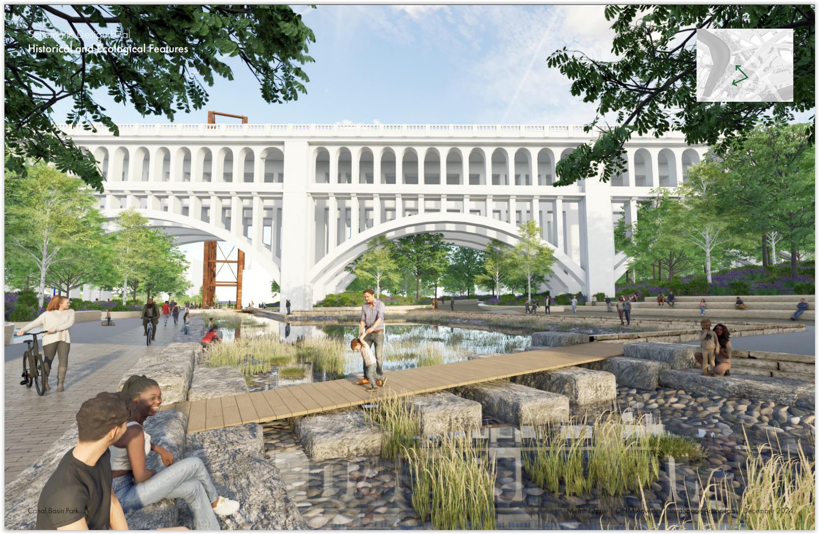
Ecological features like a stormwater collection system for the park will show the progress made in cleaning up the Cuyahoga River in the last five decades. Historical features like Berean sandstone blocks from former bridges and buildings in the Flats will be used as design elements. This view looks north along the former canal bed, alongside the Towpath Trail at left (Merritt Chase).
“It really is our responsibility, not yours, and the government agencies to hold firm that we are not going to let the edges of the river be private,” Kuri said. “So I’m going to challenge you (park planners) to challenge us to show it, and to show what the problem is (by identifying the boardwalk gaps).”
Educational features include the river-themed playground. And the stormwater collection system for the park will be a clean-water feature that celebrates Cleveland’s and the Cuyahoga River’s role in blazing a path for the passage of the 1972 Clean Water Act. The river did so by being so polluted for a century that it repeatedly caught fire — the last time in 1969.
Concepts for the park were the result of public input provided last summer. Input came from a walking tour and online surveys. But most of the input came from people living well beyond easy walking and biking distances of Canal Basin Park. That concerned commission member and Ward 17 Councilman Charles Slife, an avid cyclist and occasional jogger who said Edgewater and Wendy parks are popular because they have lots of parking.
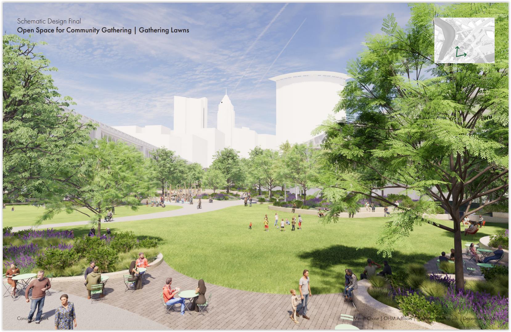
Looking east across the planned gathering lawns toward downtown, the Detroit-Superior High Level Bridge is at left, or north. The Greater Cleveland Regional Transit Authority Red Line viaduct is behind the trees at right. On the other side of the lawns in the background is a proposed playground (Merritt Chase).
“If we want this investment to be something more for the city and the region and not just for the people who live within a half-mile, we’re going to have to think through how people get there,” Slife said. “I don’t think that we can be so naïve as to suggest that you can do it in a multimodal way because if I’m going to a picnic with my kids in the park and I’m carrying all my stuff and everything, I’m not looking to park a mile away or take the bus. That’s just not reality.”
“I simultaneously don’t want us to lose park space for big empty parking lots but I want us to acknowledge the success of the Towpath, the success of other parks does correlate in my opinion of having access by car,” he added. “How do we create that balance here and make sure that the activity that we see in those renderings is reality?”
Planning Commission Vice Chair August Fluker, who had the gavel as chair for today’s meeting because Kuri was in attendance only by video, said park programming as much as park designs need to make the place attractive on a year-round basis. That can be done by making it more of an educational site with interpretive features to teach people what this site really means, he said.
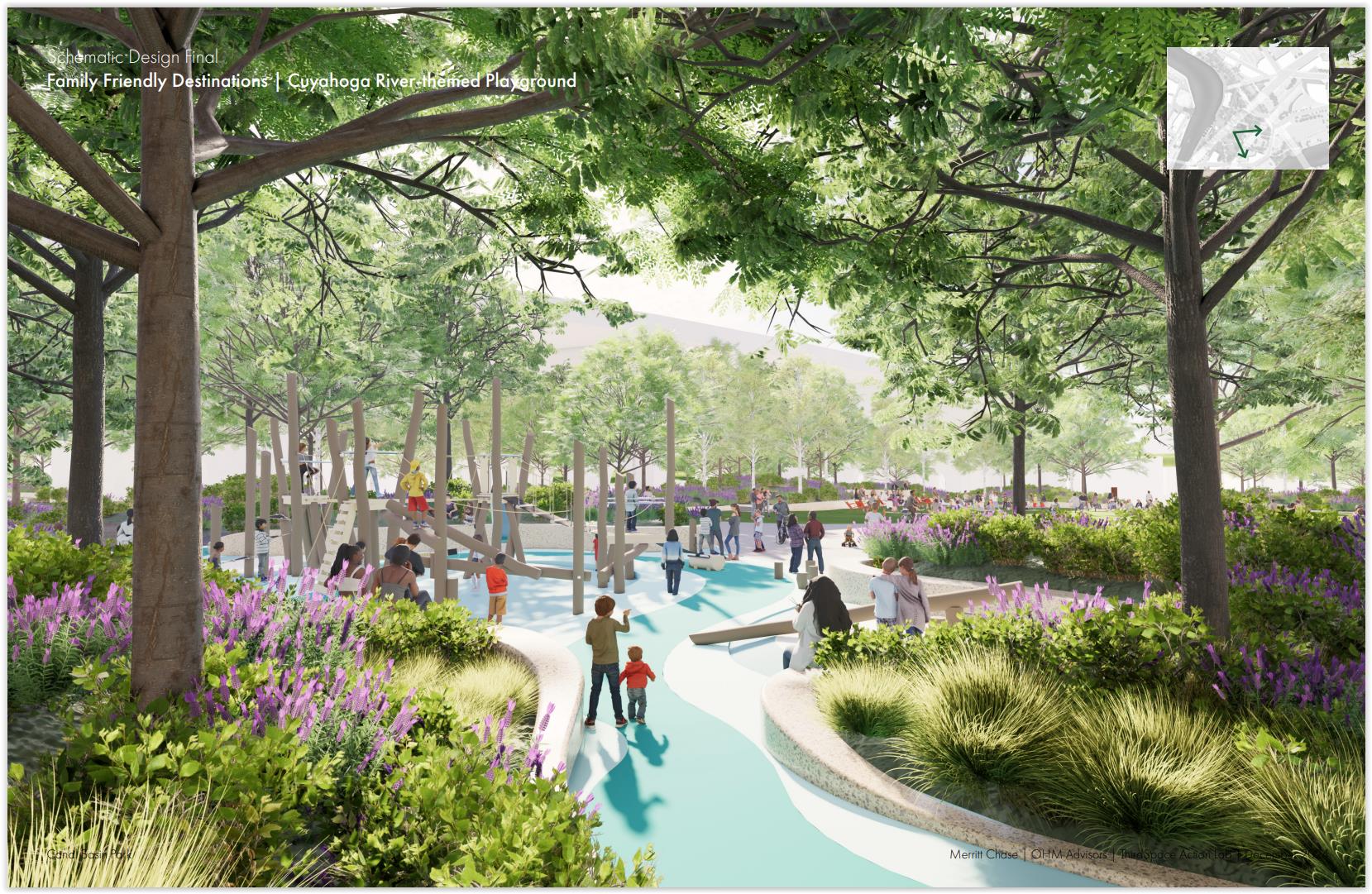
A river-themed playground is proposed, with the meandering Cuyahoga River shown on the grounds and play features are built next to or bridging over the “river” to create a fun and educational setting (Merritt Chase).
“We never ever talk about four seasons,” Fluker explained. “I’m sitting here and thinking, this is great for two-and-a-half or three months, maybe five if you’re lucky. So how does that look? How do we ensure this is an area for all seasons?”
The park will highlight several histories. One is river history that goes back 12,000 years to the end of the last ice age. Although native human use of the land and European-American based civilization arrived before the Ohio Canal, the canal’s arrival in 1827 dramatically accelerated Cleveland’s development. Railroads arrived in 1849 with the Cleveland, Columbus and Cincinnati Railroad building south from the lakefront through this site and across the river through Scranton Peninsula.
With the dredging of the Cuyahoga River north of Newburg to make it navigable, the north end of the canal was filled in and leased by the city to the Valley Railway to link with Akron for the next century starting in 1879. The railroad era in this location ended 45 years ago and was left in limbo as commuter parking lots and vacant, overgrown land ever since.
END