
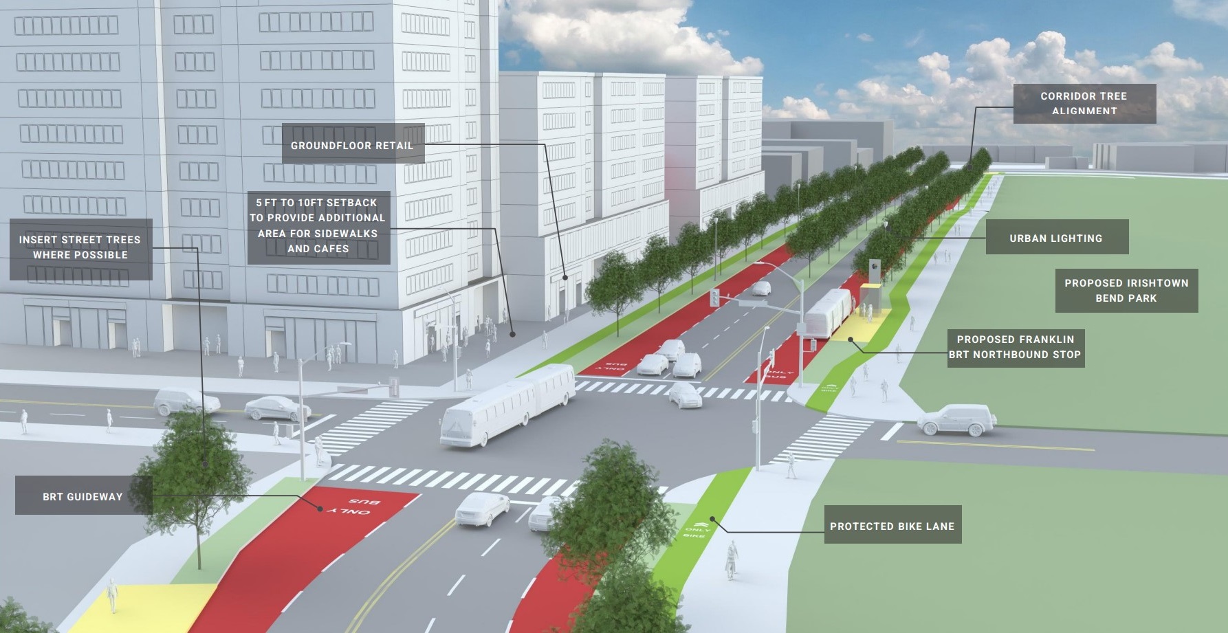
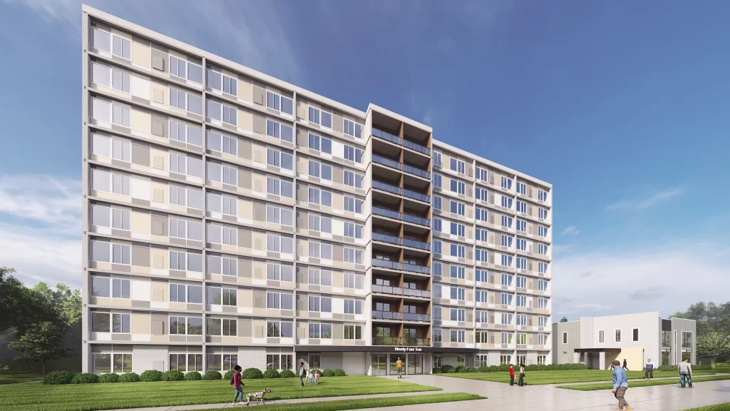
Looking north along West 25th Street from the intersection of Franklin Boulevard in Cleveland’s Ohio City, the 25Connects plan would do more than speed up bus service between downtown and Old Brooklyn. It could also help energize high-density, mixed-use development called Transit-Oriented Development that boosts transit ridership, walking and biking thereby reducing car dependency as this conceptual design shows (GCRTA). CLICK IMAGES TO ENLARGE THEM
City Planning Commission approval is expected tomorrow for a comprehensive plan to enhance public transportation service along the busy West 25th Street corridor between downtown Cleveland and the Old Brooklyn neighborhood.
The proposed 25Connects bus rapid transit project would speed up Greater Cleveland Regional Transit Authority (GCRTA) buses by 10-20 percent, tapping federal transit funds to redesign the street and create bus-only lanes similar to the HealthLine along Euclid Avenue. GCRTA is undertaking 25Connects with design assistance from Stantec Inc. of Edmonton, Canada and Seventh Hill LLC of Cleveland.
The plan is to turn West 25th into a “Complete Street” with protected bike lanes, landscaped sidewalks, public art and, of course, lanes for cars and some on-street as well as off-street parking. It has broad involvement and support from a variety of stakeholder groups, according to GCRTA.
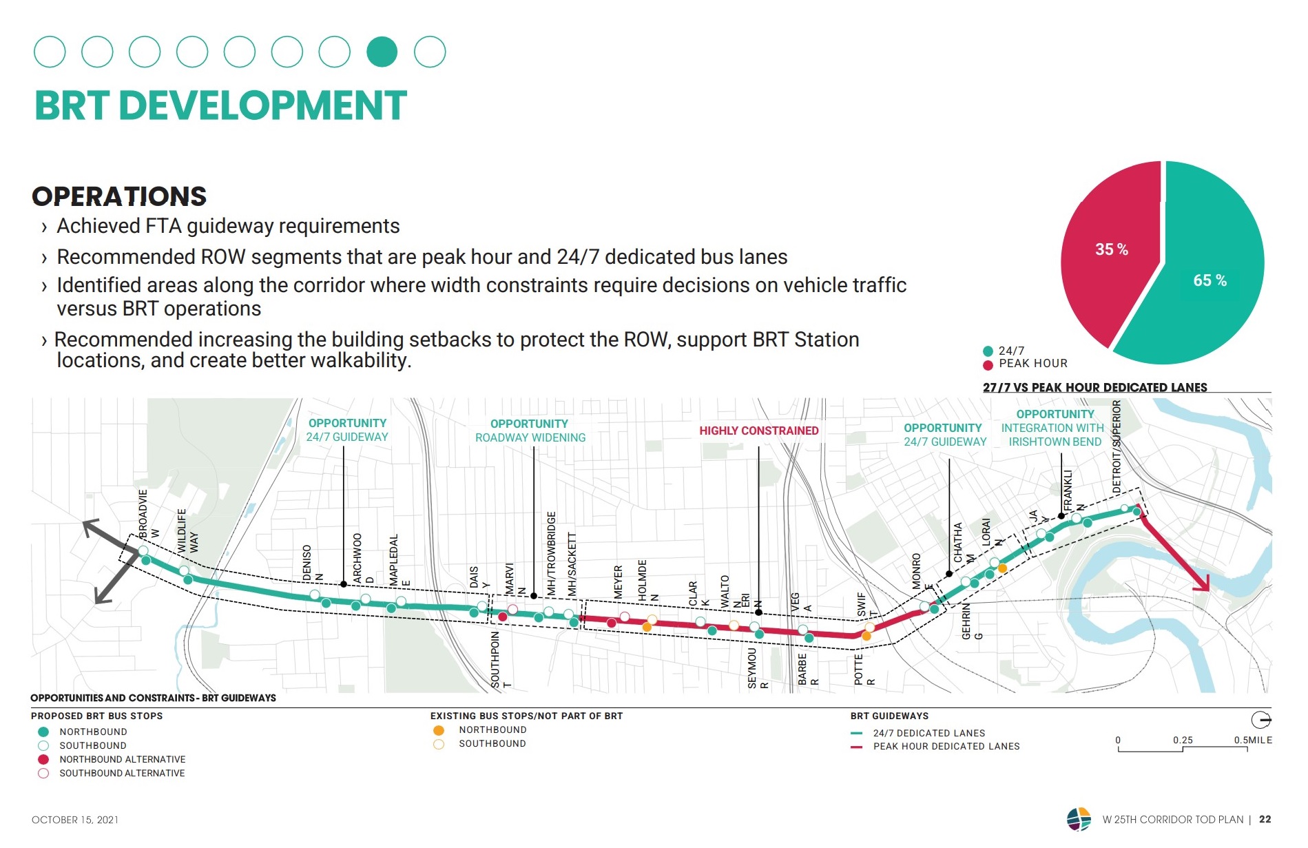
With north at the right side of this image, the 25Connects project area is shown here along with areas of opportunity and constraints to offer dedicated bus and bike lanes. The area of proposed investment extends along West 25th Street from Old Brooklyn to the intersection of Detroit Avenue in the Hingetown section of Ohio City. Along the way, faster buses on mostly dedicated lanes serving more substantial bus stops and neighborhoods with denser, mixed-use, walkable developments are envisioned. To receive federal funds, bus trip times must be reduced by at least 10-20 percent, requiring some design challenges through some highly constrained sections of the corridor (GCRTA).
This latest 25Connects presentation to be given before the City Planning Commission tomorrow will focus on Transit-Oriented Development (TOD) with the proposed creation of a TOD zoning overlay, a streamlining of the process for approving mixed-uses and establishing new parking requirements.
The parking requirements include a maximum of one parking space or stall per housing unit, a 0.15-stall-per-unit for visitor parking, and no parking required for ground-floor or retail uses having less than 25,000 square feet of floor space. That would reduce construction costs for new developments and maintenance costs for owners of existing buildings. There are also provisions for moving some on-street parking into off-street decks and lots to open up the street for dedicated bus and bike lanes.
There may be possibilities for securing federal transit funds, Build America Bureau financing or other incentives such as Ohio’s new Transformational Mixed-Use Development tax credit to fund costly parking decks, public spaces and other features of dense, mixed-use projects, project backers say.
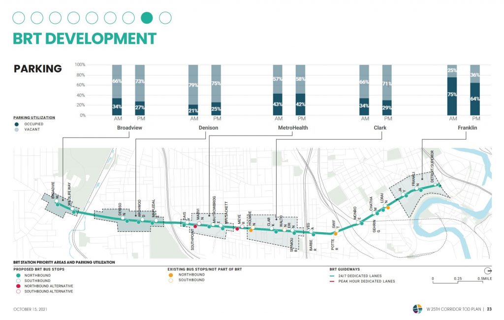
The availability of parking is frequently perceived to be a critical issue in the West 25th Street corridor. But that often means that someone couldn’t find a parking space near the front door. In reality, parking is plentiful throughout most of the corridor. Only at the far northern end is the parking supply constrained. Thus removing on-street parking is unlikely to keep motorists from finding parking spaces within a short walk of their destination (GCRTA).
They also point out that by reducing parking requirements, reducing car dependency and providing off-street parking such as through publicly funded garages may prove to be a significant boost to TOD-scale development along West 25th. Already, there has been a great deal of development activity along this stretch of West 25th in recent years.
TOD is a development theme which emphasizes density, mixed-use, walkability in a transit-served setting; it de-emphasizes surface parking lots especially in the front of single-use buildings set far back from the street.
GCRTA’s TOD plan included a market assessment and singled-out five basic areas — Broadview Station, Denison Station, MetroHealth Station, Clark Station and Franklin Station — where this approach could attract significant additional development. The goal is to promote investment in Old Brooklyn, Brooklyn Centre, Clark-Metro, La Villa Hispana, Tremont and Ohio City.
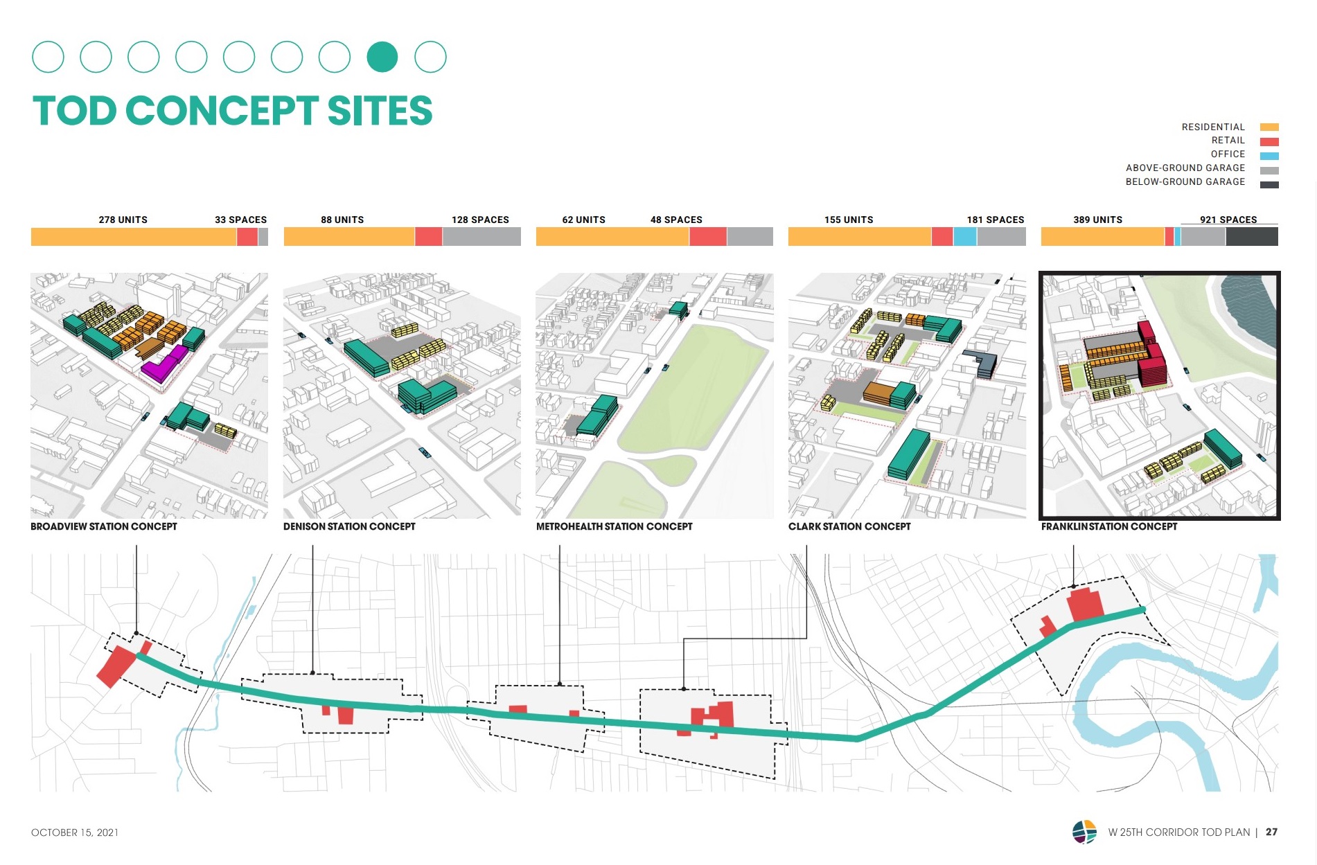
These five concept sites for Transit Oriented Development were identified by the 25Connects study and subjected to market studies and design criteria under proposed zoning changes and parking restrictions (GCRTA).
Interestingly, an emerging development cluster near the Nestle L.J. Minor Factory is not included in the plan and the number of bus stops in the area are to be reduced. Although major developments were built (Front Steps’ St. Joseph Commons) or are underway (Mavrek Development’s Treo), significant amounts of undeveloped land remain in the area. That includes a large, never-developed parcel to be acquired by Knez Homes.
Extra attention was paid in the presentation to the Franklin Station area, notably the existing Lutheran Hospital parking lots. The largest of those is a 5-acre, 530-space lot north of Franklin and west of West 25th. It is across the street from the site of the half-funded Irishtown Bend Park. Housing built here would offer access to the park, nearby stores and restaurants, plus tremendous views of downtown and the Cuyahoga River valley.
At the future Franklin Station, the conceptual TOD plan says there is a market for nearly 400 housing units, neighborhood retail and a small office presence in buildings 7-10 stories tall. And it would require 900-plus structured parking spaces above and below ground for the new development, the hospital and for Irishtown Bend Park.
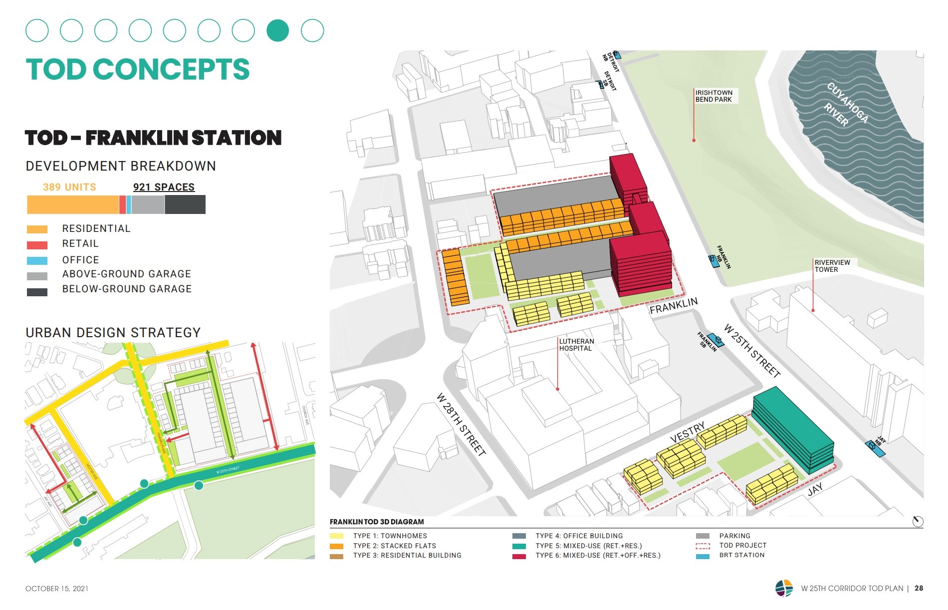
The largest of the proposed TOD concept sites based on market studies is the so-called Franklin Station, located in the vicinity of West 25th Street and Franklin Boulevard. Two Lutheran Hospital parking lots totaling 680 spaces are proposed for a mix of housing types and land uses, as well as off-street parking (GCRTA).
The cost of such a large parking deck has precluded development here. But the 25Connects plan could tap public funds to construct it and keep the parking off West 25th north of Bridge Avenue. With West 25th freed of on-street parking in this area, a conceptual rendering (see lead picture) shows a landscaped, multimodal boulevard replacing what is now a tired, barren street scene.
With city approval of the 25Connects plan, GCRTA can advance the project into the preliminary engineering and design phase next year while applying for competitive state and federal funds to start construction by 2025. The 25Connects plan will boost a transit corridor with 1.7 million bus boardings per year.
Although cost estimates upwards of $40 million have been thrown around, a definitive figure is unavailable. For example, construction of the HealthLine in 2008 cost $220 million. A less intense revitalization of Clifton Boulevard as the Cleveland State Line through Cleveland’s Cudell-Edgewater neighborhood and into Lakewood in 2016 carried a $20 million price tag.
END
- Cleveland, Bedrock seek $1 billion for riverfront development

- CRE industry lauds Bibb’s construction permit overhaul

- Bridgeworks design evolves again – minus hotel
- Cleveland Kitchen wins $10M in tax credits
- Welleon gets an ‘A’ in testing Cleveland’s market

- EPA gives Greater Cleveland $129.4M for five solar arrays, reforestation

Comments are closed.